The Chart Room Gallery
Reproduced
from the Geography & Maps Collection of the U.S. Library of Congress.
As Art Director
at a large digital print service, owner Stephen Rock had the privilege to work
on a number of projects with the Library of Congress Geography and Maps Division
reproducing works in their collection . Projects ranged from a large offset
project to fine art digital reproductions to providing the printed charts for
a handcrafted leather bound atlas. Now through his own studio, Stephen is printing
high quality limited editions of some of these historic maps. Working with high
resolution scans from compressed MrSid files from the Library's archives, these
maps are given minor cleaning of tears and marks and adjusted for output on
a Roland HiFi inkjet printer. Using pigmented inks and printing on Concorde
Rag fine papers, these prints are done at 1440 dpi and have an archival lightfast
rating up to 130 years plus. Many maps are scanned in sections and are
"stitched" back into one image. Once final imaging is done, the file is burned
to CD and printed as requested.
For information
about purchasing these and other fine map reproductions please contact Stephen
Rock at Rock's Studio 206.935.5788
or contact Jeffrey Moose at the Jeffrey Moose Gallery 1333 Fifth
Avenue, Rainier Square in downtown Seattle Washington 206.467.6951
Northwest Collection Southwest Collection World
Discovery
Northwest
Collection
The following maps are images of the
Pacific N.W. and the surrounding region.
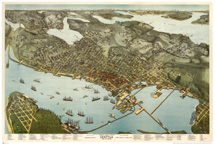
"Seattle
1891"
This wonderful panoramic view of Seattle just 18 months
after the great fire is seen from above Alki beach across Elliot Bay to the
Cascade Mountains. The ferry docks at Leshi and Madison, the logs on Lake Washington
and the train tracks laid across the tide flats of the Duwamish are beatifully
rendered by original artist Augustus Koch. This map is 20" x 30" and printed
on Concorde Rag Fine Art paper. It is available as a Limited Edition of 250.
Top of Page
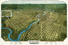
"Spokane
1905"
Looking northeast toward the Idaho border, this panorama
shows early Spokane and the surrounding area. It includes an inset of Fort Lawson
as it was in 1905. This map is 20" x 30" and printed on Concorde Rag Fine
Art paper. It is available as a Limited Edition of 250.
Top of Page
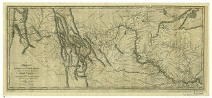
"Track of Lewis & Clark"
1804
Taken from the original notes and charts of the expedition,
this map of Lewis and Clark's tracks is a beautiful piece of history. Showing
the tribes that were encountered and numbering the "souls" they were strong,
this map follows the route to and from the Pacific Ocean.
Available at 14" x 32" on Concorde Rag Bright White paper from
an edition of 250.
Top of Page
"View of Victoria, Vancouver
Island"
This view from 1860 by H.O. Tiedemann shows the harbor
full of tall ships, Fort Victoria across the bay , the Government Buildings
and Indian canoes entering the harbor. The copy in the L.O.C. collection
is badly damaged but the image is still quite beautiful. Because of the amount
of repair needed to rid the image of cracks, mold and other marks I have chosen
to leave this view "as is" for reproducing, giving it a truly authentic old-print
look.
Printed on Concorde Rag Fine Art paper and available as a
Limited Edition of 250.
Top of Page
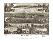
"Olympia, Washington"
1903

Detail of inset illustration with Mount Rainier in the
background and fishing boats on Puget Sound. Other insets include the Seal of
the State of Washington, coal mining in the Cascade Mountains and views of the
city of Olympia and its historic buildings.
Printed on Concorde Rag Fine Art paper and available as a
Limited Edition of 250.
Top of Page
Southwest
Collection
The following maps are images of the Southwestern United
States, Mexico and the Baja of California.
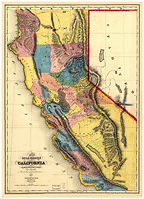
"California
Gold Region, 1851"
Showing the areas of gold mining during the
boom times of the California Gold rush, t his map is 20" x 30" and printed on
Concorde Rag Fine Art paper. It is available as a Limited Edition of 250.
Top of Page
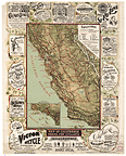
"Map of California Roads for
Cyclers, 1895 "
Produced during the bicycle haydays, this
map outlines the routes for recreational biking around the Calfornia region.
Around the outside of the map itself are ads for products relating to the new
leisure sport. Printed on Concorde Rag Fine Art paper and available as a Limited
Edition of 250.
Top of Page
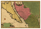
"California as an Island,
1720"
La Californie ou
Nouvelle Caroline : teatro de los trabajos, Apostolicos de la Compa. e Jesus en
la America Septe. / par N. de Fer, Geographe de sa Majesté Catolique.
Before California was accurately mapped and
the west coast charted, it was reported that California was indeed an island.
This early work shows what was then referred to as "New Carolina". Printed on
Concorde Rag Fine Art paper and available as a Limited Edition of 250.
Top of Page
World
Discovery
The following are maps of the world
and the journeys of the discoverers who mapped our lands. Please visit again as
more maps will be added.
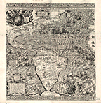
"1562 Diego
Guttierez Map of the Western Hemisphere"
Reproduced from one of the rare treasures of the Geography and
Maps Division of the Library of Congress, this work is from one of only two
prints known to exist. Engraved by Heronimus Cock and embellished with superb
detail, this work is an example of the art of map making as it existed in the
16th century. Sea creatures abound, giants rule Patagonia and Caesar rides a
shell drawn by seahorses toward the new continent. Newly discovered California
is noted and scenes of ship wrecks, battles and sirens of the seas are abundant.
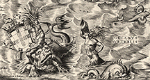
Detail showing the coat of
arms for Portugal and many creatures of the south Atlantic Ocean.
This map is
available as a Limited Edition of 250 in either 20" x 22" or 40" x 42" size
prints.
Printed on Concorde Rag Fine Art paper and available as a
Limited Edition of 250.
Top of Page